Eyes from Orbit: Mpho Sadiki's Satellite View of African Wetlands
- Dimpho Lephaila
- Jun 12, 2025
- 5 min read

Wetlands are the lifeblood of our landscapes often unseen yet utterly vital. But what if the key to knowing where these crucial ecosystems are and how they change lies far above, in the silent gaze of satellites? The story of Mpho Sadiki reveals how.

Born in Ha-Manavhela, a village nestled in Ha-Kutama within the Limpopo Province, Mpho's early life unfolded within a close-knit community. Her initial schooling took place there, a foundation upon which she later built, completing much of her secondary education at Ridgeway College in Louis Trichardt. This pivotal opportunity, provided by the Sumbandila Scholarship Trust, broadened her academic and personal horizons.
In her schooling, Mpho describes herself as having been a "fairly capable student," particularly in mathematics and geography. Yet, like many young individuals, the definitive trajectory of her future career remained an open question.
Mpho admits her impactful career unfolded "almost by accident" when she and her Headmaster explored university options in the University of Pretoria’s prospectus.
Given her strengths in geography and maths, their focus led them to the geography department where they encountered Geoinformatics. Upon reading its description – analysing and visualising geographic information with technology for real-world problems – "it licked. I knew instantly this was it," Mpho recalls.

Mapping the Journey to Sustainability, Powered by Geospatial Intelligence
Mpho's early journey in Geoinformatics sparked a deep interest in remote sensing and Earth observation for environmental challenges.
Now, this path has her as an Earth Observation Data Scientist at Digital Earth Africa, harnessing satellite data for sustainable development and decision-making in Africa.
Complementing this vital work, she is also pursuing a PhD, with her research deeply intertwined with her professional endeavours, focusing on the remote sensing of wetlands. Her doctoral research strategically examines how satellite data can improve the classification and monitoring of these crucial ecosystems to bolster conservation and refine land management amidst climate and land-use change.
Her current project, Mpho explains, "uses satellite images to help find, map, and monitor wetlands across Africa." These vital areas are crucial for water storage, wildlife, and flood protection. However, "in many parts of Africa, we do not have good maps of where these wetlands are or how they are changing, " she adds. Satellite imagery like this offers a powerful lens to begin filling those crucial mapping gaps.
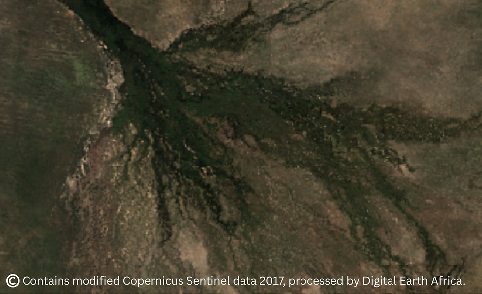
To address this critical gap, Mpho's research skilfully uses data from satellites to find wetlands. Her analysis focuses on key indicators like "how green the vegetation is, how water moves across the landscape, and the shape of the land" to discern and categorise different types of wetlands.
She’s also actively building machine learning models to predict where wetlands are likely to exist, even in hard-to-access or seasonally dry areas. The overarching goal is to "develop open, repeatable workflows that make it easier for others to generate accurate wetland maps using free satellite data and open-source tools." These adaptable workflows, she notes, "can be adapted and applied in different countries or regions, making it possible for planners, researchers, and conservationists to make better decisions based on up-to-date and reliable information."

The Cloud's Smart Path to Sustainable Wetland Data
Mpho's emphasis carries the weight of urgency, "Wetlands," she states, "are some of the Earth's most valuable, yet threatened, ecosystems." She elaborates, noting that "across Africa, they are vital for water, livelihoods, and climate, yet remain largely unmapped and unprotected. This lack of accurate wetland maps and data," she stresses, "leaves decision-makers in the dark."
Imagine trying to protect these crucial areas without knowing where they are or how they're changing. Mpho's research steps in, using satellite technology, and open data and open-source tools to illuminate these hidden landscapes and empower action across the continent.
For Mpho, the exciting heart of her research lies in the infrastructure provided by Digital Earth Africa, making scalable, continent-wide wetland monitoring a reality. It organises vast amounts of satellite data into a readily usable format.
In her own work, Mpho is actively developing workflows for wetland monitoring using this very infrastructure.
The cloud-based environment empowers Mpho to conduct complex data analysis and mapping remotely, eliminating the need for advanced hardware. This universal accessibility allows anyone, anywhere, to engage in open workflows for environmental monitoring across Africa, ultimately supporting sustainability. But before the data comes the landscape, and every workflow starts with places like this.

When Research Becomes Real
"A moment that really stayed with me was the first successful run of my full wetland classification workflow across South Africa," Mpho shares. "I had only tested it on smaller areas before, so seeing it scale and produce usable outputs felt like a true breakthrough. It gave my research a tangible and impactful quality."
The significance of that moment grew even more when she realised that the same workflow could be used by others across Africa. "That shifted my perspective, and it’s something that still motivates me to make it more accessible and impactful for environmental action."
Mpho’s connection to her rural South African roots gives her research deep personal meaning. Wetlands, often the "quiet backbone of rural life," are disappearing unnoticed. "I want to change that by making wetlands more visible, using accessible tools and open, scalable workflows to support better protection across Africa," Mpho asserts. She speaks openly about this mission, and the broader promise of African-led innovation, on global stages like The Economist’s Sustainability Week.

Life Beyond the Satellites – Moments of Recharge, Melodies, and Meaningful Reflections
Beyond the demands of scientific work, Mpho finds balance in life’s simple pleasures. She values time with loved ones and says, "I also really enjoy my own company, it’s how I recharge." Music is a big part of her world. "Singing brings me so much joy and calm, no matter what’s going on," she says. If she weren’t a scientist, she reflects, "I’d probably have pursued music. I’ve always wanted to be a singer."
Mpho encourages aspiring scientists, "do not be discouraged if you don’t have everything figured out at the start." She describes her entry into Geoinformatics as "almost by accident," but says it turned out to be "a perfect fit." Her advice is simple, "stay curious, explore different paths, and be open to new ideas." She adds, "Be kind to yourself and take things one step at a time. And remember why you’re doing it – connecting your work to a bigger purpose will keep you going."
In closing, Mpho reflects on her journey, which has been anything but linear. She acknowledges the unexpected twists and turns along the way but affirms that every step has been valuable. Her research in wetland conservation shows how data can drive real-world change, fuelled by her deep passion for using technology and open data to protect Africa’s vital ecosystems. For her, it’s a reminder that science is about making a tangible difference.
If these wetlands weren't the very lifeblood of our landscapes, why would their loss matter so deeply?
Photo credits: Mpho Sadiki
Connect with Mpho Sadiki on LinkedIn
Read more science stories


Comments